Yellowstone and Grand Teton National Parks by National Geographic Maps - Trails Illustrated

Yellowstone and Grand Teton National Parks

National Geographic Maps - Trails Illustrated
National Geographic Maps; 2010 edition
May 2010
Map Pack Bundle] (National Geographic Trails Illustrated Map) Map
WSBN
0
Readers
0
Reviews
0
Discussions
0
Quotes
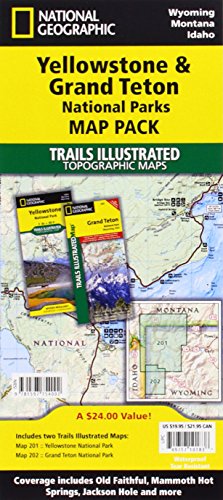
• Waterproof • Tear-Resistant • Topographic MapSeeking the best combination of detailed maps and value for your trip to the Yellowstone and Grand Teton area, then get our bundle pack. It includes both Yellowstone and Grand Teton National Park Trails Illustrated Maps, providing you coverage of the entire region, while saving you over 15%. Like all Trails Illustrated maps, the Yellowstone Grand Teton Bundle set is frequently revised and printed on waterproof, tear-resistant material to stand up to all conditions. Includes UTM grids for use with your GPS unit.Map Scale = 1:126,720 & 1:80,000Sheet Size = 37.75" x 25"Folded Size = 4.25" x 9.25"
Join the conversation

No discussions yet. Join BookLovers to start a discussion about this book!

No reviews yet. Join BookLovers to write the first review!

No quotes shared yet. Join BookLovers to share your favorite quotes!

Earn Points
Your voice matters. Every comment, review, and quote earns you reward points redeemable for Bitcoin.
Comment +5 pts Review +20 pts Quote +7 pts Upvote +1 pt
BookMatch Quiz
Find books similar to this one
About this book
Publisher National Geographic...
Published 2010
Readers 0